North American winters are still delivering devastating snowstorms, with hurricane-force winds that leave thousands without power.
So it may surprise you that winters are the fastest-warming season across most of the U.S.
What this means for the future of snowfall is complicated: A warmer planet could fuel heavier snowstorms under certain circumstances, even as snow declines in many areas.
What’s going on with winter weather?
From 1970 to 2024, average winter temperatures rose in 235 out of 241 locations in the U.S. studied in one analysis, by an average of 4 degrees Fahrenheit.
Cold snaps, on average, are becoming shorter. And the number of days with temperatures below 32 degrees F has declined — and is expected to continue to drop across the country.
Looking at the high latitudes of the Northern Hemisphere, “the rate of spring snow decline has been as dramatic as the rate of Arctic ice loss,” according to the National Oceanic and Atmospheric Administration.
How warming scrambles weather patterns
Overall, a warming atmosphere means more evaporation from both land and sea, so there’s more moisture in the air — 4% more moisture per degree F rise in temperature.
That leads to extremes: Hotter, drier areas tend to get even drier and have less rainfall, since the evaporated moisture rarely meets the colder temps that turn water vapor into liquid. (Other factors, such as air circulation patterns, also play a role in precipitation shifts.)
In areas that do get precipitation, they get more of it: more rain (and flooding) when temps are above freezing, and when temperatures (less frequently) drop below freezing, there’s a greater chance of snowstorms that break records.
So while the average amount of snow is declining in many areas of the U.S., the amount of snow that falls during intense snowstorms could increase in certain locations.
Why a warming Arctic matters
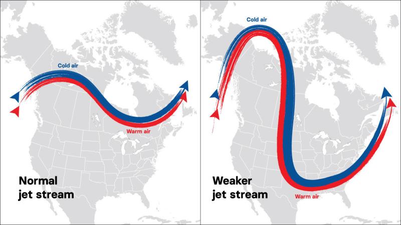
Another factor could also be fueling stronger snowstorms in the eastern and southern U.S.: the jet stream.
While usually referred to as singular, there are actually two jet streams — relatively narrow bands of strong wind that blow from west to east around the globe above the Northern and Southern Hemispheres.
These jet streams run along the boundaries where hot and cold air meet. The greater the temperature differential, the greater the force of the jet stream.
In recent years, researchers have found evidence that strong warming in the Arctic — it may be heating nearly four times as fast as the rest of the world — can weaken the northern jet stream by decreasing the temperature differential along this warm air-cold air boundary.
That makes it easier for the jet stream to be pushed and pulled out of its normal path, which can allow frigid polar air to penetrate farther south than normal.

The way forward is clear
Preventing the worst effects of climate change is possible.
Join EDF — and our 3.5 million members and activists — in advancing bold climate solutions to ensure a safe and healthy future for everyone.


